Seed Collector Mobile App

Programs:
Figma
Role:
Product Designer on Terraformation Seeds Team; collaborated with the Lead Designer and Product Manager
Impact
The design team created an intuitive way to digitally map and monitor seeds on seed collector's mobile devices while they collect on various forestry sites.
Cut down manual seed tracking by leveraging existing seed data
By using Hawaii State Seed Bank and Terraformation's seed databases make it easier to predict any seed collection trends, such as species maturity and environmental threats. This cuts down the current manual labor of seed collectors tracking this data in the field and provides valuable information for seed collectors to reference while collecting.
Improved collaboration and planning on the forestry team
Through the implementation of this new digital system, we allowed seed collectors to upload their findings about the seeds being collected to Terraformation's seed database, which gives the entire forestry team context about when to collect or plant specific species.
Customer + Business Problem
Customer
Seed collectors on a forestry team need to be able to track and monitor the seeds they collect and store in their seed banks. Seed collectors mainly need to be able to document seed species, seed collecting time periods, and any potential threats to a collection site.
Business
Terraformation has a goal of selling 10,000 seed banks to their partners. The Seed Collector Mobile App was meant to pair with the Seed Bank Sensor Kit Display, as software to support partners after they receive their seed banks.
Solution
Building an intuitive seed collecting app that allow seed collectors to document and monitor seed species, seed collecting time periods, and any potential threats to collection sites.
**The flows below are my contributions to this app, not the Seed Collector app experience in full
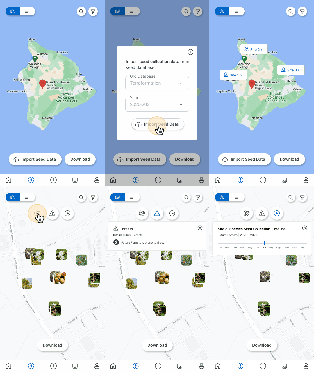
Map View: The Map View shows seed collection sites and data associated with seeds on a map. The map helps seed collector locate different seed collection sites as well as helping them navigate while collecting in the field. Map View also contains seed data and history which is useful for future seed collections.

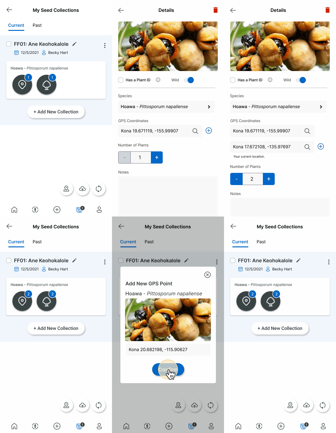
My Seed Collections allows users mark the location of specific seed species. This is useful for forestry teams to collect seed data for the future. Seed collectors can find all of the seed data logged in one spot.
Add GPS Coordinates: User can mark plant species locations through documenting GPS coordinates on site.

View and Edit Seed Collections: Users can view and edit past seed collections, as well as being able to create new entries. These seed collection entries are organized by site.


User Research
Since Terraformation is a startup, the company doesn't have much of an external user base to pull from - so the design team used our own Forestry Team members as the measuring stick for the user needs that have to be fulfilled.

Seed Collector, collects native seeds out in the field and drop them off at their seed bank to be stored for eventual out-planting.
Feedback Loop:
Our team set up weekly meetings to share designs with the Forestry team to ensure that our designs were providing value and meeting their needs. The Seed Collector App had already been previously designed and we were tasked on making the experience more intuitive and valuable to the Seed Collectors. We gained many valuable insights from these meetings that directly translated into the creation of the flows below.
Key Takeways:
1. Users wanting to view sites on a map in order to orient themselves
2. The desire to import past data from their database in order to leverage information from past collections
3. Being able to view all their seed collection information in one spot
4. The ability to easily add new entries without having to enter in redundant information.